Sunday, June 10, 2012

25 Million Bricks

 
© Stuart Pearl 2012 - Click on Image for Slideshow

That's how many bricks it took to build Fort Pulaski on the coast of Georgia back in the early 1800's.

It's hard to grasp such a large number.  But it becomes more meaningful when you see the graceful shapes and curving designs created by all those bricks.
  
During our May visit to this part of the South we saw beautiful archways, deep alcoves, broad walls and vaulted ceilings as we strolled through this pre Civil War fort.

Located outside of Savannah, Fort Pulaski is one of 30 coastal fortifications built in the first quarter of the 19th Century.  It was designed to repel enemy canon attack from the sea and surrounding marshes. Its main goal was to protect the river approaches to Savannah since that port city was vital to the cotton and lumber trade.

As part of what was called the Third System Forts, Pulaski was far stronger than earlier designs.  Most of those built after 1816 still stand today. This particular fort took 18 years to build and cost $1,000,000 when it was started in 1829.
 
In April 1861 the Civil war reached the Savannah River in Georgia.The fort was supposed to protect the river mouth but quickly fell to Union bombardment.


Designed to withstand conventional attack from smooth-bore mortars it was considered invincible.  But the defenders did not count on the newly developed rifled canon.  Shells fired from those guns easily covered the distance with devastating accuracy.  The 7 ½' thick southeast wall was soon breeched and shells began entering the fort itself.  Surrender quickly followed.

Fort Pulaski is now part of the national parks system.
 
Several miles east of Fort Pulaski sits the Tybee Island Light Station.  The first lighthouse in the complex was built in 1736.  But due to storms, wind and sand erosion it was necessary to rebuild it several times since that time.

The lighthouse and its five support buildings are now surrounded by modern condos.  But for over 270 years its beacon helped sailors safely enter the Savannah River.


Wednesday, May 30, 2012

Visit With Norman Rockwell, Winslow Homer, the Wyeths and Pearl

© Stuart Pearl 2012 - Click on Image to Enlarge

Where else can you enjoy the works of Norman Rockwell, Winslow Homer, the Wyeths and at least one semi-obscure Cleveland photographer?  These can be found at the Butler Institute of American Art in Youngstown, Ohio.
 
And if you come to the opening of the 76th National Midyear Exhibition on June 24, you can also see approximately 100 new works from contemporary American artists across the country.  I was very fortunate this year to have been accepted with my ArcelorMittal Cleveland photo (above).  Over 1000 pieces are juried each year for this show and only a handful of photos are accepted. 

Florida painter Gregory Strachov was the Juror for this year's competition.  Two dimensional works in all media are featured in the 2012 exhibit.


Monday, May 28, 2012

Ribs of the Ramp

© Stuart Pearl 2012 - Click on Image for Slideshow

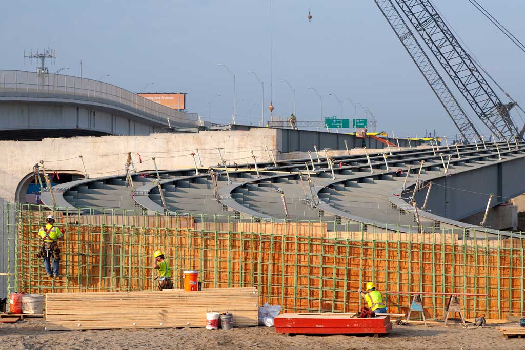
I call these "deck ribs" even though that's not an engineering term. But these 25 ton beams represent the first structural steel to be installed on the Westbound Inner Belt bridge.  They will provide the underlying support for the concrete and steel roadbed that will be built above.


5/25/12 - Looking East towards Progressive Field the Fire Museum can be seen at left near the interesection of Carnegie and Ontario.  The single pier just to the left supports the beams that will form the roadbed of the Ontario St. on ramp.  It is lower at this point since it will be bringing merging traffic up to the level of the I-90 bridge deck.  The wider pier at the right will form the actual roadbed of the interstate.

4/6/12 - Shortly after the structural steel was delivered it was positioned near pier 13.  The lower support leg on the right will be part of the Ontario St. on ramp.

5/25/12 - Looking across the Flats valley and you can see how construction is progressing.  Pier #11 (left) rises near Canal Road and still "wears" it's concrete form holding the top cap.  Piers 10 - 5 march off to the east bank of the Cuyahoga.

Friday, May 4, 2012

Rebar Moonscape


© Stuart Pearl 2012 - Click on Image for Slideshow
It looked like a rebar strewn moonscape. Progressive field spanned the horizon like a rising Earth. But there were no astronauts here - just carpenters and ironworkers on the site of Bridge Pier 14 near Carnegie and Ontario streets. 


4/6/12 - Construction was now focusing on the area of Pier 14 near the RTA Train underpass.  Earth was being regraded in preparation for the new Ontario street on ramp.  Soon the first structural steel would span the new piers as part of the new freeway entrance.


The super "H" piles had been driven to bedrock weeks ago. Now their concrete legs were rising to become the eastern most end of Innerbelt bridge one. 
Work near Progressive field is particularly challenging. Unlike the relatively flat and hard packed  spaces near W. 3rd St., auto and RTA Rail traffic create a more congested work zone near teh ballpark.  The soil texture also differs.  It is more "fluid" and requires the installation of sheet pile walls to stabilize the embankments.
Ironworkers assemble much of the rebar on the ground and then have it lifted onto the concrete forms. A lot of it still has to be bent and tied in place though.


4/6/12 - The new Ontario St. on ramp will begin at this point.  Structural steel "I" beams will ruse up a new earth embankment, across the wall (now under construction) and be anchored to the concrete legs of Pier 14.


Considerable grading of the area was necessary in preparation for the new roadbed.


3/27/12 - Pier 14 under construction


A Welder preparing for delivery of the first structural steel.


Bridge construction now stretches from E. 9th across the Flats Valley to Tremont's West side. 
5/1/12 - Even on a foggy afternoon Piers 5-9 can be seen rising up from the Flats Valley between the current Innerbelt span and the Lorain-Carnegie Bridge.

5/1/12 - The two legs of Pier 10 rise just east of W. 9th St.  The two beams at the center will provide support for the large concrete forms of the top cap.


Pier 13

5/1/12 - Pier 11 is located adjacent to Canal Rd and is about midway down the slope to W.3rd St.  The legs of this pier are spread wider than the others and concrete will have to be poured in two separate activities.  Because of its wider "stance" it is necessary to build a temporary center support to hold the top cap.

This is the inside of what will be the top cap for Pier 11.  It is sprayed with a non-stick chemical to make it easier to remove once the concrete has cured.
 
4/6/12 - Piers 14 and 13 near the RTA overpass has already received its first shipment of "structural steel." These beams will provide support for the roadbed.

The first five structural supports arrived the morning of April 3 from High Steel in Lancaster, PA.  Each beam is so huge that only one can be loaded per truck. They are 8' high, 127' long and weigh 25 tons each.


4/6/12 - Cross braces are also trucked to the site.  Six are initially bolted between each pair of girders prior to being lifted onto the piers. 


This allows the cranes to lift two beams at a time without risk of the structural steel deflecting (bending) during the raising process. Each brace weights approximately one ton and a total of eight are bolted between each pair of beams.


I call these "red ice tongs" but only because of their mechanical motion.  The ironworkers use them to lift and position the structural steel.  A lever mechanism causes them to tightly close on the beams when raised from the center, hence their ice tong motion. 

The large yellow rods are used to spread the tongs for optimum weight distribution and control when gripping the beams. Without them the 25 ton beams could dangerously swing as they are lifted.

The structural steel beams have now been placed in much of what will become the new Westbound on ramp. Further earth grading will prepare the bottom of the ramp for it's connection to Ontario St.


4/5/12 - Looking west towards Pier 13 from under the current Inner Belt bridge


5/3/12 - The metal forms on Pier 14 have been taken down revealing the completed concrete top cap.  Within a few weeks structual steel will be mounted on this pier to form the base for the west bound traffic deck of bridge one.  To the right of this pier the new Ontario St. on ramp rises up to meet it.


Ironworkers and carpenters assemble the complex pattern of rebar and lumber at the end of the "steel" portion of the ramp.  Once the form has been completed, concrete will be poured as part of the ramp embankment for the structural steel beams.


Self portrait on Pier 13

Sunday, April 1, 2012

Fog On The Cuyahoga - Atmospheric Perspective


© Stuart Pearl 2012 - Click on Images to Enlarge

We get all kinds of weather in Cleveland.  "Lake Effect" can randomly dump snow, deliver rain, and cause fog when least expected.  All this happens downtown and across both eastern and west suburbs.  But the Flats Valley creates it's own atmospheric effects. 


Cold lake water, a warmer river current and Spring showers can create some interesting photo opportunities.  Above, the 620' bulk carrier Mississagi heads out to the lake under a light rain and fog.


Tied up along Columbus Road is the 110' Apalachee.  Built in 1943 she is now a retired U.S. Coast Guard Cutter and one day will become a floating museum.  During her life she performed search and rescue, fire fighting, law enforcement and ice breaking duties on the Great Lakes.  A video of the Apalachee arriving in Cleveland on May 29, 2009 can be seen on Jeff Thoreson's blog here.

I've always tried to imbue my images with a sense of depth.  I want the viewer to feel that the near portions of a landscape are rising up to meet the eye while the far objects are receding into the distance.  This creates the feeling of dimensionality. 

I'm not attempting 3-D or stereoscopic photography. I'm just trying to create a visual experience that goes beyond the flat print hanging on the wall or being viewed on a computer monitor.


The great landscape painters faced a similar challenge long before photography was invented.  How could they represent the real world which has height, width and depth, on a flat two dimensional canvas?  They used a concept we refer to as atmospheric perspective. 

When we gaze out over a landscape, the closer foreground objects are more colorful, sharper in detail and have greater contrast.  Things in the distance are less distinct, fuzzier and the atmosphere may even look hazier.  Our brain and eyes then assemble this information into the three demensional vision of the world we see.

A walk along the Cuyahoga on a foggy day provides great opportunities for this type of photography.  Foreground objects are sharp and bold in their solid relief.  The background fades into a muted distance as colors lose their saturation and become indistinct.  Photographic compostions done under the even lighting of a cloudy day can take on a soft painterly aspect.  This can be a wonderful change from the often razor sharp aspect of today's digital photography.  There are also processing techniques in Photoshop that I use to enhance my artistic interpretations of Flats landmarks. 

A major criticism of digital photography is that often the maker creates photos that are too sharp.  They become harsh in their representation of the world.  This can have it's place depending upon the goal and intent of the photographer.  But too apply this as a broad brush to every image is a mistake.  I use the sharpenning technique sparingly - not every object should jump off the photographic canvas.  I still like to have most of my images look like traditional photographics, pleasing to the eye, and relaxing to view.


Concrete River Bank Anchors on the Cuyahoga

I've often told fellow photographers that much can be learned by walking through a museum's landscape galleries, and studying the great works. Albert Bierstadt is one such artist I've admired. He created such beautiful works as Looking Up Yosemite Valley , Rocky Mountains , and The Oregon Trail . The last is one of my favorites. I've viewed it in the permanent collection of the Butler Institute of American art.  Standing a few feet from this magnificent work it's a sight to behold.

Once the fog burns off you can see an interesting view of the Hart Crane Memorial Park on Columbus Road.  It features interesting metal sculpture inspired by Crane's poetry.  Gene Kangas designed this public art.


This last compostion was made during the 2011 Ingenuity Festival, well above the Cuyahoga.  The weather had been clear and sunny that day in constrast to my fog shrouded compositions. 

The streetcar level of the Detroit-Superior Bridge was open to the public as part of the festival.  I felt the "theater lighting" of the subway arches provided nice framing of the Flat's stacks and other bridgespans against the backdrop of a beautiful sunset.  It's here simply because I feel it's a pretty image.